General Info
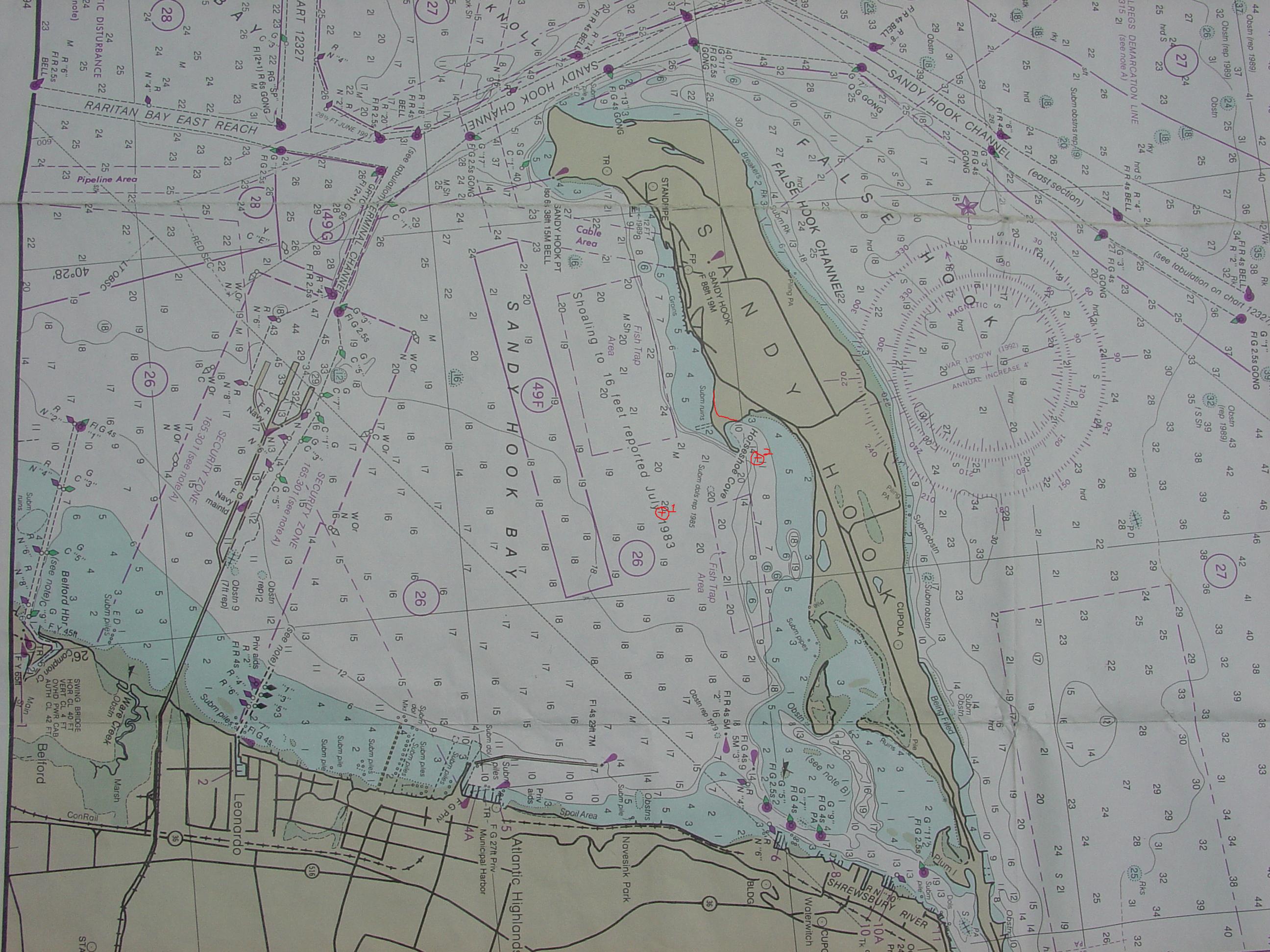
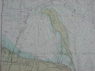 The "cove" part of Horseshoe Cove is gone. The beach that formed
the cove, which by the way, is still shown on the charts as a cove,
has been submerged for many years and now forms a north-south sandbar.
(Click on the chart on the left to enlarge.) Above water, there is just
a small beach point at most tides which is approximately marked in red
on the enlarged chart. Running directly west from the beach
are submerged pilings (charted). Running south off the beach a fair
distance west of it is the sand bar. It is often unmarked, and again
this year, there are no markers. In prior years, the southern tip of
the bar is the shallowest section and is visible at low tide. Most
larger boats enter from the southwest to avoid the bar. I'd recommend
going around the bar. You can anchor either south or east of the bar.
The tide change is about 5 feet.
The "cove" part of Horseshoe Cove is gone. The beach that formed
the cove, which by the way, is still shown on the charts as a cove,
has been submerged for many years and now forms a north-south sandbar.
(Click on the chart on the left to enlarge.) Above water, there is just
a small beach point at most tides which is approximately marked in red
on the enlarged chart. Running directly west from the beach
are submerged pilings (charted). Running south off the beach a fair
distance west of it is the sand bar. It is often unmarked, and again
this year, there are no markers. In prior years, the southern tip of
the bar is the shallowest section and is visible at low tide. Most
larger boats enter from the southwest to avoid the bar. I'd recommend
going around the bar. You can anchor either south or east of the bar.
The tide change is about 5 feet.
Although there have been fish nets in the fish trap area marked to the
north of the cove, the area to the south has remained clear.
Once a popular and protected anchorage for both power and sail,
with the cove part of Horseshoe Cove now gone, the smaller power craft
have found other locations to anchor in that are preferable such as
skull island although more hazardous for those
without local knowledge. The cove still offers plenty
of space and plenty of depth is available for larger vessels who avoid
or sneak behind the bar. It is popular with vessels coming up the coast
to get out of southeasterly wind generated offshore waves and late
season tropical storms off the eastern seaboard that can kick up swells.
There is no inland waterway from Manasquan to Sandy Hook and this is one
of the first places off shore cruisers coming up the coast can seek
a somewhat protected anchorage.
The cove is unprotected from winds from the southwest to the northwest
with the northwesterly direction having the greatest fetch. It is also
subject to wakes from the fast ferry on days that it operates and from
the early morning fishing boat races to get to fishing spots beyond
the tip of the hook.
Sandy Hook is part of Gateway National Recreational Area run by the
National Park Service and boaters can land on the beaches. However,
there are few facilities in this area without good a hike.
Directions to Horseshoe Cove
From Sandy Hook Channel G "17" at 40° 28.56 N 74° 01.67 W,
go approx 173°M toward Twin Lights until you reach the turning waypoint at
40° 26.42' N 74° 00.59' W (40° 26' 25.2" N, 74° 00' 35.4".
This point is plotted in red and circled with a 1 next to it
on the full size chart, number 12324 NJ Sandy Hook To Little Egg Harbor, linked
above. Click on the small chart above to see these red waypoint markings.
Waypoint 1 will be south west of the bar in the Cove. Go eastward at
about 80°M to Horseshoe cove at waypoint 2 at 40° 26.63'
N 73° 59.92' W (40° 26' 37.8" N, 73° 59' 55.2") and you
will be in the "cove" inside and south of the bar. You can anchor here
or move northward behind the bar. Note that the chart is in minutes
and seconds not minutes and decimal minutes as most GPSs so I have
provided the waypoints in both forms.
For those transiting the East River and NY Harbor
It would be a good idea to check for security restrictions (PDF) at
the USCG navigation center. Or try here
for more recent updates.
 The "cove" part of Horseshoe Cove is gone. The beach that formed
the cove, which by the way, is still shown on the charts as a cove,
has been submerged for many years and now forms a north-south sandbar.
(Click on the chart on the left to enlarge.) Above water, there is just
a small beach point at most tides which is approximately marked in red
on the enlarged chart. Running directly west from the beach
are submerged pilings (charted). Running south off the beach a fair
distance west of it is the sand bar. It is often unmarked, and again
this year, there are no markers. In prior years, the southern tip of
the bar is the shallowest section and is visible at low tide. Most
larger boats enter from the southwest to avoid the bar. I'd recommend
going around the bar. You can anchor either south or east of the bar.
The tide change is about 5 feet.
The "cove" part of Horseshoe Cove is gone. The beach that formed
the cove, which by the way, is still shown on the charts as a cove,
has been submerged for many years and now forms a north-south sandbar.
(Click on the chart on the left to enlarge.) Above water, there is just
a small beach point at most tides which is approximately marked in red
on the enlarged chart. Running directly west from the beach
are submerged pilings (charted). Running south off the beach a fair
distance west of it is the sand bar. It is often unmarked, and again
this year, there are no markers. In prior years, the southern tip of
the bar is the shallowest section and is visible at low tide. Most
larger boats enter from the southwest to avoid the bar. I'd recommend
going around the bar. You can anchor either south or east of the bar.
The tide change is about 5 feet.